Sound Maps for Encoding Quantitative Information
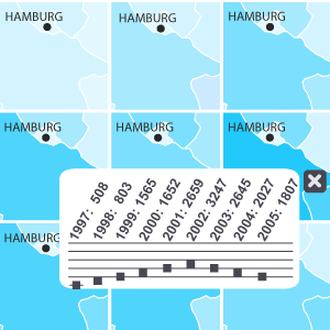
This project is based on the core hypothesis that a multicodal presentation through graphics and sound will enable a richer and more flexible provision of quantitative information and quantitative changes in cartographic displays. To test this hypothesis, in a first step, appropriate sound variables representing quantitative information have to be selected analytically. The most important variable turned out to the pitch, which is used for the subsequent design and implementation of sound maps. In a follow-up user study, selected aspects of usability are evaluated and future research questions will be deduced.
This project emanates from the project "a2maps" where we developed prototypes for presenting spatiotemporal information in animated maps with sound. This project was funded by GiN e.V.