Audio Cartography - Cartographic Visualization of Sounds
The awareness of this project is to attach importance and attention to Acoustic Geography and to analyze the spatial reference of environmental and anthropogenic sounds. This approach unites among others current environmental noise policies and common soundscape research. In this context it is necessary to create an appropriate and effective instrument to document and communicate the spatial component and reference of ambient sounds.
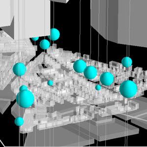
In order to accentuate and display the spatiality of acoustics, methods of traditional, digital and multimedia cartography as well as the integration of characteristic audio sequences in common 3D city models (auralization) are intended to be incorporated into the concept of Audio Cartography. Methodically, Audio Cartography enriches and increases knowledge the fields of cartography, geovisualization and visual analytics.
Audio Cartography is based on both subjectively interpreted acoustic phenomena and technically measured acoustic data. Furthermore, socioeconomic and geographic information are taken into account and are correlated with acoustic occurrences. The input data for the cartographic visualizations range from sound source differentiation, distance, dominance, distribution, etc. as well as population density and meteorological data.
Responsible researchers
Prof. Dr. Jochen Schiewe
Dipl.-Geogr. Anna-Lena Kornfeld (former lab member)