Semi-automated extraction of information from large-scale historical maps (finished PhD project by Inga Schlegel)
Historical
maps allow us to backtrace urban processes during the past. Regarding
cartography as an explorative tool we are able to identify former
buildings and
streets and analyze spatiotemporal patterns of different ages. These so
called Geocomputational Approaches
are applied to
compare historical with current geodata in the course of this PhD
project.
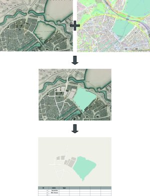
Due to the distinction between historical paper maps and today’s common geodata in digital form this project aims at making the former as analyzable as current geodata. As a result, ancient designations, addresses and other database-based information on geometries and thematic content can be obtained.
This project intends on the development of a methodology to directly compare the temporally disparate geodata by assigning semiological characteristics (e.g. color, fill pattern, line type and width) from current to historical geodata or vice versa. Accompanied by the avoidance of information overload and saccade movements the user’s cognitive perception is encouraged. Cartographers, historians, urbanists and risk researchers shall benefit from quantitative as well as qualitative information and consistent representations of the acquired geodata throughout ages.
Sources:
OpenStreeMap
(2017) / Lindley,
W., Davies, B. R. & Knight, C. [Ca. 1:10.000]. London:
Chas, Knight & Co., 1841.