Deep Learning methods for cartographic generalization based on geographical vector data (PhD project by Martin Knura)
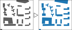
First experiments with deep learning in the field of map generalization adapt models from image processing, creating input data by rasterizing geographical vector data. While the benefit of using the well-adapted deep learning models for image processing is undoubted, using only derived images as input comes along with a clear limitation in data richness and information compared to the underlying vector data, while rasterization introduces uncertainty and fuzziness into the generalization process.
By contrast, using vector-data as input would skip the rasterization process with all its problems, with the potential to preserve parts of the well-established workflow of map generalization and allowing further manual editing afterwards. Therefore, this Ph.D. project aims at developing an end-to-end deep learning model for map generalization based on vector data input.
The first step of the Ph.D. project is to develop and test encoding schemes that allow deep learning models to directly learn from vector data. In the next step, the focus is on defining loss functions to learn how to adequately modify (i.e. generalize) geometries. The aim of the last step is to develop an end-to-end deep learning model that is able to orchestrate the generalization of a whole map scene consisting of several geometry types and objects. .